Restricted civilian area
A place where community and nature work together to sow seeds of hope
人与动物成为家族 散播希望之种子的地方
The sunlight shines on land where shadows of separation lie. The community cultivates this abandoned land in a hope that it will one day flourish.
在分断的影子里,隐藏的土地也迎来了阳光。耕耘被遗弃的土地,重新散播种子,营造生命的空间。我们可以在民间人统制区相遇向着世界重新崭露头角的就像阳光的希望。
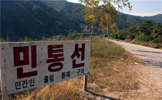
<Sign at north of Civilian Control Line> Photo by the KangwonIlbo
Civilian Control Zone—another buffer zone wider than the DMZ
比DMZ更厚的另一个缓冲地带,民间人统制区
North of the borderline neighboring the DMZ, we find soldiers’ wearing black shades controlling the pedestrians. This is an indication that you have reached the fixed area between the DMZ and its border, an area restricted to civilians. The Civilian Control Line (CCL) is one of the control lines that were designated together with the birth of DMZ and is the most southern line among such lines. This restricted area controls the traffic of civilians passing through. The DMZ was designed as a buffer zone, but the risk of military collision still exists within this region. This is the reason why the CCL was set below the DMZ, to restrict civilians passing through.
与DMZ相邻的接境地区往北走过一段距离,就可以遇到戴着黑色墨镜,阻止我们继续向前的军人。位于DMZ与接境地区之间的一定空间,即‘民间人统制区’非常靠近的地方。随着DMZ的诞生,韩半岛拦腰分断的几条线中最南边的线,那就是民间人统制线(民统线,Civilian Control Line:CCL)。民间人统制区是一定部分限制普通人通行的区域,为了防止双方冲突,虽然指定了DMZ这一缓冲地带,但依然在这一带存在军事冲突的危险。所以,在DMZ下面设定民间人统制线,限制着民间人的出入。
In February 1954, the CCL was referred to as ‘Gwinongseon’, which regulated civilian farming near the DMZ under the authority of the eighth US army commander. Since then, the nation’s forces were in control of the MDL defense and the name ‘Gwinongseon’ changed to CCL. From June 1959, land utilization for civilian farming was permitted within a specified area where operational and security maintenance was unaffected. Restrictions were implemented to regulate the bypassing of civilians, cultivation and land ownership within the region. The area of the civilian control zone has been reduced as the CCL moves northwards and the military base moved 10km south from the MDL (Military Base and Protection of Military Installations Act Article 1). There are no civilian control zones at sea.
民间人统制线是1954年2月以美军第八军司令的职权,在与DMZ邻近的地区限制民间人回归农地耕农的‘归农线’开始。此后,随着国军担任军事分界线防御任务,1958年6月改称为民间人统制线,而自1959年6月份开始在军事作战与保安上没有影响的范围内,允许民间人务农的土地使用。但是,对他们也是不仅限制区域内自由出入与活动,还部分限制除了耕作权之外的土地所有权行使等。民间人统制区经过几次调整民间人统制线,不断往北迁移而缩小,到现在只规定为军事分界线以南10公里以内(军事基地与军事设施保护法第5条)。在海上没有设定民间人统制区。
■ The scope of civilian control zone
民间人统制区范围
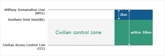
■ Adjustment of the CCL to the North
民间人统制线北上现况
Jan 1983 1983.01 | The first scope of CCL set 最早民统线范围设定 | 20~40 km South of MDL (DMZ included) 军事分界线以南20~40公里(包括DMZ) |
Dec 1993 1993.12 | First adjustment 1次北上 | 10~20 km South of MDL (DMZ included) 军事分界线以南10~20公里(包括DMZ) |
Jan 1997 997.01 | Second adjustment 2次北上 | 5~15 km South of MDL (DMZ included) 军事分界线以南5~15公里(包括DMZ) |
Sept 2008 2008.09 | Third adjustment 3次北上 | 5~10 km South of MDL (DMZ included) 军事分界线以南5~10公里(包括DMZ) |
Villagers of the CCL living closest to the DMZ
最靠近DMZ生活的民统线村庄人们
During the ceasefire negotiation in 1953, the South and the North agreed on the location of one village within the DMZ. This village formed Daeseong-dong in the South and Kijong-dong in the North; however, it cannot be accessed at any time. The distance between the divided villages is only 800 meters. High flagpoles form points of reference within both villages. The North Korean flagpole in Kijong-dong village is 160 meters high, and has been recorded in the Guinness Book of Records. The national flagpole in Daeseong-dong reaches 100 meters, symbolizing the competitive nature and tension between the two villages of the North and the South.
虽然不是可以随意进出的地方,DMZ内也有村庄。1953年停战协定当时,南北双方同意在DMZ内各设置民间人居住地,而根据同意在南侧设置的就是大成洞自由之村,而北侧是机井洞村庄。两个村庄的距离仅仅是800米,是可以用肉眼可以确认互相村庄的近距离。在两个村庄最显眼的是非常高的各自的升旗台。机井洞村庄的人共旗升旗台的高度达到160米而登载于吉尼斯纪录,而大成洞自由之村的升旗台高度也达到100米,成为南北的两个村庄之间流淌的看不见的竞争与紧张的象征。
There are CCL villages located along the Southern Boundary Line (SBL) where the tention is less than that of the villages in the DMZ, namely Tongil-chon and Haemaru-chon in Paju-si. Tongil-chon is known for its cultivation of the ‘Jangdan soybean’. With the support of Paju-si, Tongil-chon hosts the Jangdan soybean festival in Jindong-myeon, Paju-si every year. The name of Haemaru-chon comes from the term ‘hae’, meaning ‘sky’ and ‘maru’ meaning ‘hill’. The size of this farming village is smaller than Tongil-chon; however it offers many attractions.
经过南方警戒线进入民间人统制区内,就可以看到比DMZ内村庄稍微不紧张的民统线村庄。其中,坡州市有统一村与HAEMARU村等民统线村庄。统一村生产叫做‘长短豆’的特产,并在坡州市积极的支援下,举办长短豆庆典等充满活力。意味着天的‘HAE’与意味着山坡的‘MARU’的合成词-‘HAEMARU村’之名的HAEMARU村位于坡州市镇东面。虽然比统一村规模小,但也是充满温馨魅力的农村村庄。
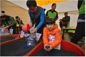
<PajuJangdan soybean festival held every November> Photo by Paju city
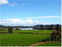
<Landscape of Haemaruchon> Photo by Paju city
Preserving the natural ecology and habitat of migratory birds
维持天赐自然生态的候鸟乐园
When one thinks of the DMZ’s civilian control area, we think of a land home to a ‘blessed natural environment’. A place where cranes are in abundance, and martens and goats are in continuous search for food. The woods are a restricted area to civilians. The plain is visited by many people for its plethora of bird species in the sanctuary. The Dutayeon Valley is filled with Manchurian trouts swimming upstream, and the Yongneup Swamp of the Daeamsan Mountain is located in the Ramsar wetlands (elected and registered by the Ramsar association, recognizing the importance of wetlands). To visit these regions, one must make prior reservations, as the number of visitors is increasing, due to the growing interest in its natural ecology.
民间人统制区在这段期间我们想起DMZ时自然而然想到的是具有‘天赐的自然环境’的土地。在广阔的旷野上,被指定为天然纪念品的丹顶鹤群翱翔天空,跨越在草丛里觅食的山羊与貂生活的地方,那里大部分不是DMZ内而是民间人统制区。作为世界级候鸟栖息地,很多人踏访的铁原平野;蛙鱼顺着溪谷逆水而上的头陀渊;韩国最早登录拉姆萨尔湿地(拉姆萨尔协会肯定湿地的重要性之后,指定、登录、保护的湿地)的大岩山龙沼等,都在民间人统制区内。虽然来到这里之前,提前预约并申请等伴随着繁琐,但因为只能在民间人统制区才能看到的自然生态的神秘感,来到这里的人们越来越多。
Local residents attempted to turn the civilian control zone into a place where both people and animals could coexist in harmony. Yangji-ri in Cheorwon-gun is known as the ‘migratory bird village,’ since many species of birds appear in the Togyo Reservoir. From early September, hundreds of thousands of wild geese, thousands of cranes, and about ten thousand white-napped cranes visit the reservoir to spend the winter. Yangji-ri residents ‘fulfilled an independently run crane conservation association to protect endangered cranes, as well as to feed the birds and eagles in order to sustain the ecological village.
如此,人类与动物聚在一起和谐生活的民间人统制区的生活,都是地区居民们努力的结果。民间人统制区的居民将他们辛辛苦苦营造的生活空间,欣然分享给这里的动物。铁原郡阳智里因为在土桥水库每年飞来各种候鸟,被称为‘候鸟村庄’。9月初开始,数十万只大雁、上千只丹顶鹤、上万只白枕鹤为了过冬来到这里。阳智里的居民为了保护罕见的丹顶鹤,不仅自发组成韩国丹顶鹤保护协会,还亲自准备候鸟食物,甚至飞鹰的食物,逐渐成为生态村庄。
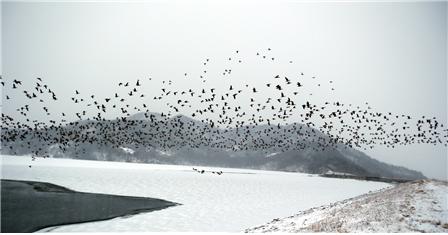
<Migratory birds at Togyo Reservoir, Yangji-ri, Cheorwon-gun> Photo by Cheorwon County Office
<铁原郡阳智里土桥水库的候鸟>照片_铁原郡厅
Changes in the civilian control zone, with focus on residents’ life
民间人统制区的变化,最重要的是居民们的生活
The reason why the civilian control zone could become a place of an intact natural ecosystem is the limited access and the prohibition of development, thereby controlling the anthropogenic influences. In other words, the civilian control zone had been excluded from the development plan. Public investment lacked due to a declining popularity; however, after the 1990s, certain changes were made. Requests from local residents for easier access required the CLL to move northwards so as to obtain facilities necessary to meet the demands and regulations of diversified farming. Villages in the Northern area of the CCL merged southwards, decreasing the number of villages within the civilian restricted area.
民间人统制区之所以能成为自然生态系的宝库,是因为进出限制与开发抑制,没有受到人们的破坏。换言之,也意味着这段期间民间人统制区在长期开发计划中被疏远。普通市民也没有对民间人统制区给予足够的关心,民间投资也没有实现。民间人统制区就像名字,任何事处于‘警戒’状态,停滞在原地。但是90年代之后,民间人统制区也开始发生了变化。随着地区居民们要求,民间人统制区进出程序得以简化,并伴随着多角务农的设施规制缓和等要求,民间人统制线逐渐向北迁移。所以,民统线北方地区的村庄编入到以南地区,民间人统制区内村庄数量相对减少。
The range of the CCL villages is gradually decreasing, and sadly the lives of the residents’ have not been improved much. The number of people leaving the community due to many regulations is increasing. Recently, a change in awareness about the DMZ has captured the attention of people, showing the value in the civilian control zone’s natural environment and its role as the outpost of a unified Korea. Nevertheless, we should always remember that the civilian control zone is not a mere “space” shaped as a relic of warfare nor an object for developmental activities. It is a place for life. It is a site with an amazing diversity of living creatures, which could have been possible due to the local residents who are still there to ensure the vitality of the land. This is why humans should become the priority in planning the future of the civilian control zone.
民统线的范围和民统线村庄也逐渐减少,但可惜的是生活在这里的居民生活没有发生大的变化。他们陆续离开依然还有很多规制的这些地方。最近,随着对DMZ的认识发生变化,因为民间人统制区自然环境的价值与统一韩半岛的前哨基地作用,人们的视线正在聚在这里。我们不可或忘的是,不可以将民间人统制区单纯地认为这是作为战争遗物形成的‘空间’。因为那里是等待开发的对象同时又是自然生态系的宝库,更加是人们生活的空间。在没有人守护的这片土地,撒播新的生命种子,在漫长的几十年岁月中守护他们宝贵的生活空间,这就是每当想到民间人统制区的未来,应该以‘人类’为优先考虑对象的理由。
Published in
December 1, 2014
Modified in
December 3, 2016
-
source
Past that was left for the future, DMZ (2010) HahmGwang-bok, Education Center for Unification, Ministry of Unification
Research on reduction method of CCL region’s ecosystem cause of damage and effects (2011), Park Eun-jin, Gyeonggi Research Institute
Research on correcting the notion of development and direction of policy within theGangwon border line area’s (2011), Kim Beom-su, Gangwon Development Institute
Research on efficient management plan of the DMZ and neighboring areas (2002), Korea Environment Institute, Ministry of Environment


comment