The emergence of the DMZ and current status
The DMZ - A land of agony and hope
必须访问的痛苦与希望之地
An unsettling cold breeze was once the feeling you experienced when entering the DMZ. It was quite fearful when I think back; however, it is time to view the DMZ from a new perspective, with eyes wide open. Now, the area is surrounded by a deep sense of hope.
不知为何,好像四季只刮起冷风。只要一想到,就觉得有些可怕。但是,现在只能睁大双眼,注视着DMZ。过去感到遥远的这个地方,现在只能用力吸进不断围绕着的希望的味道。

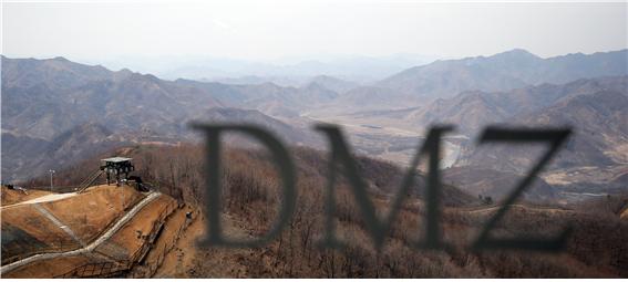
<A landscape of the Chilseong Observatory in Hwacheon> Photo by KangwonIlbo
A desolate yet peaceful space where the gunfire stopped
在枪声停下的地方诞生的凄凉的和平空间
“Ships were retreating from North Korea’s grayish sea water and silver aircrafts silently landed on their airfield. No more wars. But no peace, no victory. This is ceasefire.”
“在海上,舰艇从北韩的灰色海上撤退,银灰色的飞机在他们的机场静悄悄地降落。现在没有战争。但是,和平与胜利也没有。这就是休战。”
- This kind of war, (2000) T.R. Ferhenback
At 10:00 am on July 27th 1953, United Nations Forces Commander, alongside representatives from North Korea and China, gathered at Panmunjeom. The purpose of this meeting was to continue ceasefire negotiations that were ongoing for the past two years. Without hesitation or silent greetings, documents were prepared and signed by both parties in a total of twelve minutes. This was a pivotal moment in history, when three years of war looming over the Korean Peninsula, ended. Gunfire has ceased to exist, resulting in neither of the oppositions’ in victory. The Korean War left us in irrevocable pain, as well as unsolicited difficulties. The DMZ-un approachable land,crossing the Korean Peninsular from East to West.
1953年7月27日上午10点,联合国军司令官和北韩与中国代表相聚板门店。这是为了进行两年多的休战会谈打上句号。没有握手,也没有搭讪,在沉默中,双方在提前准备的文件签名,所需时间仅仅是12分钟,就这样长达三年覆盖整个韩半岛的炮火与枪声终于停止。虽然枪声停止,但没有胜者与败者的战争,6.25战争除了给我们带来无法回顾的伤痕与痛苦之外,还遗留了亟待解决的作业。横跨韩半岛的无法靠近的土地,这就是DMZ。

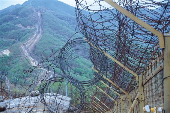
<An endless line of cease-fire > Photo by Jun Young-jae
According to the dictionary definition, ‘Demilitarized Zone’(DMZ), refers to a “prohibited military zone by international treaty or convention” The 2km DMZ is used as a space of refuge from the MDL. This decision was made based on Article 1: Section one, from the ceasefire agreement. Its role is to be a military buffer zone in order to prevent military crash between the North and the South.
辞典含义来看,‘Demilitarized Zone’之简称的DMZ是‘非武装地带’之意,指的是‘根据国际条约或公约禁止武装的地区’。韩国的DMZ是根据1953年7月27日签署的停战协定第1条1项(军事分界线与非武装地带),定义为‘确定一个军事分界线,双方自这条线各自后退2公里而设定的空间’。为了防止休战状态的南北韩军事冲突,起到军事缓冲地带作用。
2km North and South of MDL, the DMZ, is a total width of 4km.Taking the Korean Peninsula into account, the DMZ’s length is 248km (155miles), measured from the mouth of the Yellow Sea’s Imjingang River, to the East Sea’s Myeongho-ri, Goseong-gun. Its combined area is 1.5 times bigger than the city of Seoul and 1/250 of the Korean Peninsula’s total area. From the Imjingang River’s estuary to the far end of Ganghwado Island is a neutral region forming part of the Han River estuary, which the North and South are permitted to use. This is in contrast to the DMZ, where the North and South’s private usage is restricted.
DMZ是军事分界线的南北方向各2公里,共4公里宽度的空间。横跨韩半岛的DMZ长度是自西海的临津江下游开始到东海的高城郡明湖里为止,共248公里(155海里)。这是首尔市面积的1.5倍,占韩半岛整个面积的1/250。而且,作为‘汉江下游中立地区’,这里有自临津江下游到江华岛末岛为止,允许南北两侧利用的地区。这与陆地上的DMZ禁止南北韩民间利用的情况相反。
A 248km heart-breaking boundary, cutting across our mountains and streams
横穿我们的山河、长达248公里的令人痛心的分界线
Certain boundaries cannot be crossed carelessly, which were born right after the agreement of armistice. These boundaries are recognizable as Military Demarcation Lines (MDL), namely the Southern Limit Line (SLL); Northern Limit Line (NLL); and Civilian Control Line (CCL). SLL is 2km south of MDL, and CCL is within 10km south of MDL when seen from the side of South Korea (Protection of Military Installations Act: Article 1). Regions adjoined to the CCL are called ‘border-line areas’.
随着签署停战协定,韩国产生了无法随意跨越的几条线。这就是军事分界线(Military Demarcation Line:MDL)与南方警戒线(Southern Limit Line:SLL)、北方限界线(Northern Limit Line:NLL)、民间人统制线(民统线、Civilian Control Line:CCL)。在南韩看,从军事分界线向南2公里有南方警戒线,在军事分界线10公里以内向南划着民间人统制线(军事基地与军事设施保护法第5条)。而且,邻近民间人统制线的地区被称为‘接境地区’。
The MDL, which forms part of the DMZ, depicts an askew shape, slightly diverged from the 38th parallel. This is the result, as the MDL was not designed in dis accordance with the 38th parallel but with the military confrontation line during the ceasefire agreement.
成为DMZ基准的军事分界线稍微脱离当初的38˚线,成为稍微歪斜的模样。这是因为不是按照停战协定当时正确的38˚线,而是以南北韩军事对峙线为准划分军事分界线。

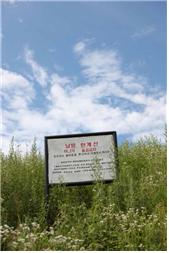
<SBL sign>photo by Jun Young-jae
The southern boundary line (SBL), which is 2km South of MDL, is familiar territory. Through press media such as TV networks and newspapers, soldiers have been seen on duty in the front line alongside barbed-wire fencing. Many people have mistaken the barbed-wire fence for the MDL, but this front line is SBL. There are no barbed-wire fences or entanglements at MDL. Dangerous stakes only exist at certain points every 200m along the boundary of the Imjingang River to Goseong-gun (total 1,292 stakes).
军事分界线往南2公里处有南方警戒线,这里倒是我们熟悉的地方。只要是韩国国民,至少一次通过电视或报刊看过在最前方的铁栅栏巡逻的军人。很多人误以为该铁栅栏是军事分界线,但其实他们在铁栅栏巡逻的地方就是‘南方警戒线’。在军事分界线没有铁栅栏,也没有铁丝网。这里只有自临津河畔到高城郡以200米间隔竖立的1,292个木桩而已。
The purpose of the Civilian Control Line (CCL) is to control citizen access. The area between MDL and CCL is called the Civilian Control Area. An act was instated in February 1954 to prohibit the access of civilians in order to protect military facilities and to effectively execute military operations.
民间人统制线就如其名,是警戒民间人进出的区域线。军事分界线与民间人统制线之间的区域称为‘民间人统制区’。这是1954年2月确定的空间,是为了保护前方配置的军事设施、圆满执行军事作战,禁止民间人随意居住或进行产业活动的地方。
DMZ: A reformed structure and significance
模样、宽度、含义都有变化的DMZ
Today, the DMZ has transformed itself from its original scope and purpose. To secure the highlands for advantageous observation, the North and South forced their way through the structure, altering the DMZ’s 4km width, resulting in the MDL as the center. At certain points, the width has been reduced to a few hundred meters; therefore, the necessity to accurately determine the DMZ’s area is stronger than ever before.
现在的DMZ从本来的范围与目的上,其面貌发生了相当大的变化。以原来的军事分界线为准,宽4公里的DMZ为了南北双方确保观察上有利的高地,向里面推进而产生了宽度低于4公里的地方。根据地区,也有了其宽度缩短到几百米的地方。所以,通过正确的调查,需要确保DMZ的实际范围必要性也日益增大。
The DMZ is not the only area where the dimensions have been distorted. The CCL has also transformed itself from its original form. The CCL was initially set within a range of 5~20km from the south of the MDL, but now it has reduced down to 10km.Villages were formed within the Civilian Control area, which gradually disabled the stringent restrictions and regulations.
当初的设定范围发生变化的不仅仅是DMZ。民间人统制线也与初期的范围不同。民间人统制线是自本来的军事分界线向南5~20公里间隔设定,但现在其范围缩短到10公里以内。民间人统制区形成村庄,人们也不断聚集,本来严格的进出限制与各种规制也逐渐缓和。
It’s already been 60 years since the appearance of the DMZ. Like our life changes, the DMZ has changed too. Unknown land across the wires came to us as a land that should be visited one day. We have inherited the DMZ as the Cold War’s legacy, but now it is time to think about how we will pass it on to future generations.
DMZ诞生已经过了60年,我们的生活发生了变化,而DMZ的面貌也发生了变化。铁丝网外面的‘不知晓的地方’成为‘不管何时必须去一次的地方’,来到了我们的身边。我们把DMZ作为冷战的遗产继承下来,但现在是我们应该再次深思要不要给我们的后代作为遗产来继承的时刻。
Published in
November 11, 2015
Modified in
December 3, 2016
April 07, 2017
April 13, 2018
-
source
Past that was left for the future, DMZ (2010) HahmGwang-bok, Education Center for Unification, Ministry of Unification
「Research on DMZ’s spatial area」(2007), Kim Chang-hwan, the Geographical Society in Korea
「DMZ discussion: History of concepts andgroping new paradigm」(2013), Lee Jung-cheol, Kangwon Development Institute
「Research on pushing ahead South-North cooperative project for DMZ’s peaceful uses」(2009), Kim Young-bong, Lee Seung-bok, Kim Eun-jung, Korea Research Institute for Human Settlements


comment