The five northwestern bordering islands
Giving hope to the blue ocean The five islands protecting the northwest region
在碧绿的浪涛中载着希望守护西北国土的五个岛屿
There is a place that can be enjoyed for hours, while watching waves and seagulls from land. At the end of the yellow sea, there are islands that are mysterious as we learn more. Watching the invisible ocean boundaries, there are people dreaming of unification.
从陆地出发,波涛与海鸥为伴,疾驰几个小时才能到达的地方。碧绿的西海有很多神秘的岛屿。望着肉眼看不到的大海分界线,有些人培育着统一之梦。
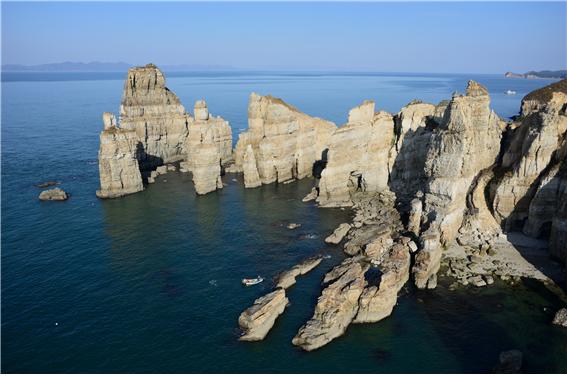
<Northern most point of the five northwestern islands, Dumujin rock, Baengnyeongdo Island> Photo by Ongjin County Office
<西海五岛最北端白翎岛的头武津奇岩>照片_甕津郡厅
The five islands protecting the northwestern sea above the ocean excluding the DMZ
没有DMZ的海上,守护西北海上的五个岛屿
On July 27th 1953, new lines and space such as the MDL, civilian control area, and the borderline area appeared on the Korean Peninsula together with a ceasefire agreement. Then, how about in the sea? If there were non-accessible lines on the land by South and North, shouldn’t it be the same in the sea?
1953年7月27日,随着停战协定,在韩半岛陆地产生了军事分界线、DMZ、民间人统制区、接境地区等前所未有的新的线与空间。那么,大海又如何?陆地上划着南北互相无法逾越的线,那么海上也会不会一样呢?
‘The five northwestern islands’ is the area covering Yeonpyeongdo, Soyeonpyeongdo, Baengnyeondo, Daecheongdo and Socheongdo Islands, and nearby seas. The five northwestern islands began its history as the security center of the Korean sea, around the same time the DMZ appeared for the first time. The protected zone of the military installations within the five northwestern islands takes up 40.3% of the Ongjin-gun’s sea area, and 93.5% of the five northwestern islands’ total area. That’s how close the five northwestern islands are to North Korean land. Daecheongdo and Socheongdo islands are 202km away from Incheon, but it is only 19km away from Jangsan point, Hwanghaenam-do. The distance from Baengnyeongdo Island to Incheon is 222.2km and 15km from Jangsan point, Hwanghaenam-do, while Yeonpyeongdo and Soyeonpyeongdo Islands are 145km from Incheon, which is the closest distance from Incheon among the five northwestern islands. But it is just 10km away from Bupo-ri, Hwanghaenam-do.
‘西海五岛’是位于韩国中西部海上的延坪岛、小延坪岛、白翎岛、大青岛、小青岛等五个岛屿与包括邻近海域的地区。守护韩国国土最西北端海上的西海五岛也是在DMZ诞生的那个时期,作为韩半岛海上安保中心地区,谱写着新的历史。西海五岛的军事设施保护区域面积是甕津郡整个行政区域的40.3%,占西海五岛整个面积的93.5%。西海五岛位于离北韩非常近的距离。大青岛与小青岛位于离仁川202公里的距离,但离黄海南道长山串仅有19公里的距离。白翎岛离仁川是222.2公里,但离长山串是15公里距离,延坪岛与小延坪岛离仁川的距离为145公里,是西海五岛中离韩国国土最近,但离黄海南道夫浦里仅仅是10公里距离。
■ The five northwestern islands’ geographical overview
西海五岛的地理概观
Section 区分 | Yeonpyeongdo, Soyeonpyeongdo Island 延坪岛、小延坪岛 | Baengnyeongdo Island 白翎岛 | Daecheongdo, Socheongdo Island 大青岛、小青岛 |
Administrative district 行政区域 | Yeonpyeongyeon, Ongjing-gun 甕津郡延坪面 | Baengnyeong-myeon, Ongjin-gun 甕津郡白翎面 | Daecheong-myeon, Ongjin-gun 甕津郡大青面 |
Location 位置 | East longitude 125° 43′ North latitude 37° 40′ 东经125°43′ | East longitude 124° 53′ North latitude 37° 52′ 东经124°53′ | East longitude 124° 43′ North latitude 37° 48′ 东经124°43′ |
Distance 距离 | • Distance from Incheon 145㎞ • Distance from Bupo-ri, Hwanghaenam-do 10㎞ •离仁川距离145㎞ | • Distance from Incheon 222.2㎞ • Distance from Jangsan point 15㎞ •离仁川距离222.2㎞ | • Distance from Incheon 202㎞ • Distance from Jangsan point 19㎞ •离仁川距离202㎞ |
Surface 面积 | 7.28㎢ | 50.99㎢ | 15.60㎢ |
Coast line 海岸线 | 36.67㎞ | 56.75㎞ | 41.24㎞ |
Uninhabitable islands 无人岛屿 | 10 | - | Gapjjukdo 甲竹岛 |
Second northern limit line that exists in Korea, NLL
韩国第二个北方限界线,NLL
There are two Northern limit lines existing in Korea with different backgrounds and nature, even though they share the same name. One is two kilometers north from the MDL, forming the DMZ of North Korea. It is a correspondence concept of the southern limit line, which is set two kilometers south. Another NLL exists on the narrow sea between the five northwestern border islands and the North Korean territory. The familiar NLL to us usually signifies the NLL on the ocean, not the one on land. When did the NLL become known in the ocean, and what was the difference with the NLL on land?
韩国有着相同名称但诞生背景与性格不同的两个北方限界线。一个是以军事分界线为准往北后退2公里的地点设定,形成北韩方面的DMZ的北方限界线。这是跟向南后退2公里地点设定的南方警戒线相对应的概念。另一个北方限界线位于西海五岛与北韩之间窄海上。对我们熟悉的NLL(Northern Limit Line)大部分不是陆地上,而是北方限界线。海上的北方限界线是什么时候形成,跟陆地的北方限界线有什么不同呢?
The NLL in the Ocean was not formed by the ceasefire agreement. In August 1953, which was after the ceasefire agreement, UN forces Commander Mark Clark notified the North after pulling out navy troops from regions in the Yellow Sea, located North of the MDL’s western extension line and arbitrarily forming the NLL, including the five northwestern islands. And North didn’t bring up any claims. After that, the NLL was practically approved by the Inter-Korean Basic Agreement, saying that “regulate the MDL which is regulated by the NLL and controlled area by both sides”. The NLL in the sea is not an actual MDL that is specified in the ceasefire protocol, but it is a MDL in reality.
海上的NLL不是根据停战协定形成。签署停战协定签署之后的1953年8月,联合国军司令官马克·克拉克自军事分界线的西侧延长线靠北的西海岛屿撤出海军兵力,任意设定包括西海五岛的北方限界线(NLL)并通报给北韩。而且,当时北韩没有提出异议。此后,根据南北基本同意书,表示“北方限界线规定为已经规定的军事分界线与至今双方管辖的区域”,事实上认定了NLL。海上的NLL虽然不是停战协定书明示的实质上的军事分界线,但事实上也是军事分界线。
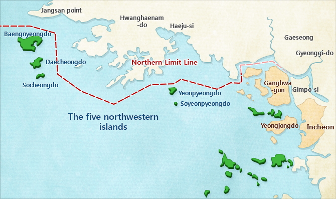
<Geographical location of the five northwestern border islands>
<西海五岛的地理位置>
The report of the abundant ecological resources, isolated but not a lonesome island
丰富的生态资源的宝库,独处但不孤单的岛屿
It is located in the isolated area in the sea that can be reached after several hours of sea voyage from Incheon, but it is not a lonely island. The northernmost island of the western sea, the Baengnyeongdo Island, is the 8th largest island in our country with 5,431 residents (October, 2015). Also, the values of the five northwestern border islands are geographically and ecologically recognized for keeping important natural views and ecosystems. There are geomorphic landscapes such as large-scale sand seashores and sea cliffs as well as a Basalt Area with high geological value. Moreover, it is the southernmost habitat of the west coast’s only marine mammal, the Baengnyeong Spotted Seal, and a paradise for migratory birds such as the stork and mallard where they arrive in flocks. The Baengnyeongdo Islands, Dumujin black sandy beach, is designated as a place of scenic beauty and protection. There are lots of plants, beaches and unique topography, which are designated and supervised as natural monuments.
位于从仁川港坐船几个小时才能到达的偏僻的海上,但西海五岛并不是只有孤独的岛屿。西海最北端的白翎岛是韩国第八大岛屿,2014年6月为准共居住5,426名居民。而且,西海五岛是具有在地理·生态学上认定其价值的重要自然景观与生态系得地方。大规模沙滨与海蚀崖等地形景观到具有地质价值的玄武岩分布地区,西海岸唯一海洋哺乳类的白翎斑海豹(天然纪念品第331号)最南方栖息地。同时也是黄雀与野鸭等每年成群过来的候鸟们的乐园。白翎岛头武津的黑沙滩被指定为名胜而受到保护,很多植物与鸟类、海边、特异地形等被指定为天然纪念品受到管理。
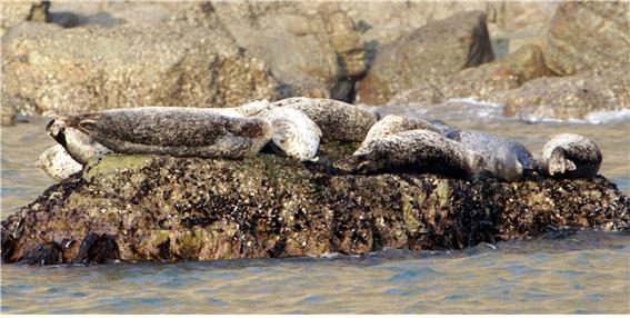
<True seals, Baengnyeongdo Island> Photo by Ongjin County Office
<白翎岛的海豹>照片_甕津郡厅
As the coastal area is located at the center of the Korean Peninsula, researching the local nature in the five northwestern border islands is changing. The development potential of this area is very high as it is the pass-through area of the main ocean traffic network. It is also a special ecological environment area where diverse ecosystems are created. If the South and North’s economic cooperation becomes activate and is supported, it is expected to have significant meaning as Korea’s another territorial resource.
位于韩半岛中央地带的沿岸地区,对西海五岛的地区特性的评价也不同。该地区是主要海上交通网的通过地区,具有非常高的发展潜力。而且,已经建设各种生态系,是一个特殊的生态环境地区。如果南北韩的经济合作激活,受到政策上的支援,则今后作为韩国的另一个国土资源具有很深的意义。
Get to know more about the five northwestern border islands
详细了解西海五岛
■ Baengnyeongdo Island
白翎岛
Baengnyeongdo Island is the northernmost island only 17km away from North Korea and our closest region to China. Historically, it has played a role as being a stopover between Korea-China sea route through the period of the Three States and Koryo Dynasty. As an administrative district, it is Baengnyeong-myeon, Ongjin-gun, Incheon and the 8th largest island. There are sea cliffs developed around the Dumujin area, a gravel shore called the Kongdol Beach, and a coastal landform such as the Sagot-dong sandy tideland where the sand is hard enough to drive cars along, and the sandy coasts are well developed. At the seaside of Jinchon-ri, Spotted Seals inhabit near the national monument, as well as the Siberian water pepper, which is a northern plant, which only grows on Baengnyeongdo Island. It is also reported the following lives in the ecosystem; The Stork, Spoonbill, Chinese Egret, Bean Goose, and falcon, which are classified as endangered wild animals and plants. There are various Unified Security Trails and tourist spots such as the unification, praying tower, unification praying headstone and Simcheonggak.
白翎岛是位于自北韩17公里的西海最北端的岛屿,是韩国最靠近中国的地区,通过三国时代、高丽时代,历史上起到韩国~中国航线的中间中途停留作用。行政区域上,属于仁川广域市甕津郡白翎面,是南韩第八大岛屿。头武津一带的海蚀崖发达,被称为豆石海岸的砾石滩、足以汽车飞驰的坚固的仕串洞沙质干汐地与沙滨等海岸地形也非常发达。镇村里海岸栖息作为天然纪念品的斑海豹,北方植物的西伯利亚辣椒只在白翎岛滋生。这里是分类为灭种危机野生动植物的黄雀、琵鹭、黄嘴白鹭、大雁、燕隼等集体栖息地的生态系的宝库。还有统一祈愿塔、统一祈愿碑、沈清阁等各种安保体验路径与旅行地。
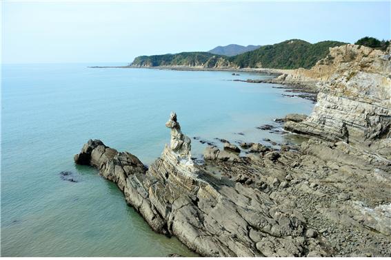
<The big burp rock, Baengnyeongdo Island> Photo by Ongjin County Office
<白翎岛龙饱嗝岩>照片_甕津郡厅
■ Daechongdo Island
大青岛
Geographically, it is located near the Southern Limit line (SLL), northwest of Ganghwado Island and Daecheong-myeon, Ongjin-gun, Incheon as the administrative district. Overall, it is made up of steep inclined mountain areas and a monotonous coastline. Daecheongdo Island is known as a good island to rest because of its clean sandy beaches and beautiful surrounding sceneries. During early spring, it is a great spectacle to see the red camellia flowers blooming, which can be seen (natural monument no.66) near Satan-dong beach, which is the northern most habitat of South Korea. A sand pile, which can’t be seen easily in Korea is formed here together with a big size coastal dune, number of sand beaches and long sand banks creating an exotic atmosphere. Fisheries are well formed around coastal areas where lots of skate, rockfish, rock trout, abalone, sea cucumber and other seafood is caught.
地理上位于江华岛西北方向南方警戒线邻近,行政区域上属于仁川广域市甕津郡大青面。整体上由倾斜度高的山地组成,海岸线大体上显得单调。大青岛因为白沙场干净,周边风光美丽,作为适合休养的岛而闻名。沙滩洞海水浴场附近还有位于韩国最北端的冬柏树滋生地(天然纪念品第66号),每逢早春可以看到漫开的红色冬柏花。形成在韩国罕见的沙山的海边,大规模海岸沙丘与多个白沙海边、长长的沙洲等相和谐在一起,演绎出异国风趣。近海形成养鱼场,可以捕捉斑鳐、石斑鱼、六线鱼、鲍鱼、海参等。
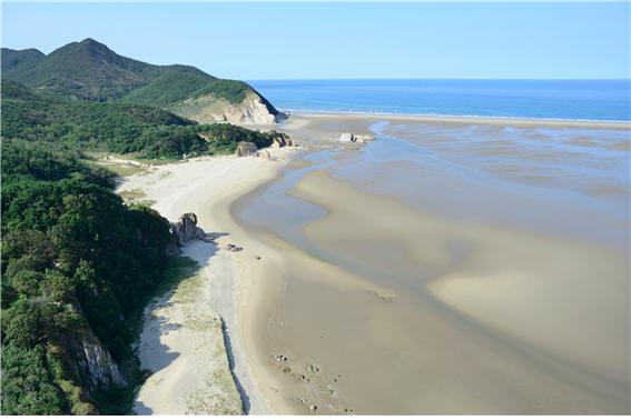
<Nongyeo beach, Daecheongdo Island> Photo by Ongjin County Office
<大青岛农与海边>照片_甕津郡厅
■ Socheongdo Island
小青岛
It is a long island stretching from the east to the west and belongs to Daecheong-myeon, Ongjin-gun, Incheon being the administrative district. Socheongdo Island is famous for its fishing spots, with various abundant marine products. Also, the ‘Bunbawi Rock’, which is named after its whitish color like it is powdered and harmonizing with the blue sea, is magnificently spread along the coastline. Bunbawi Rock also known as ‘Woltti’. It plays a role as a direction guide for ships entering the village during the final night of a lunar month. At Socheongdo Island, you can find Korea's second built lighthouse. Camping is possible around the lighthouse area where you can enjoy a romantic vacation by watching the flickering light at night.
行政区域上属于仁川广域市甕津郡大青面,东西长条状岛屿。小青岛是各种鱼种的海产品丰富的地区,整个岛作为钓鱼场而闻名。而且,小青岛与碧海相和谐,因其白如粉而被称为‘粉岩’的岩石顺着海岸线壮观地展现在眼前。因为看似在月光缠着白色带子而亦称为‘月带’的粉岩,成为漆黑夜晚从海里归家的渔船的灯塔作用。而且,小青岛有着1906年设置的韩国第二个灯塔。小青岛灯塔一带可以用帐篷野营,夜间看着一闪一闪的灯塔的灯光,享受浪漫的休养。
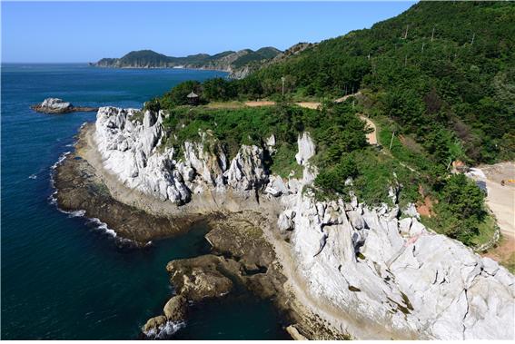
<Bunbawi Rock, Socheongdo Island> Photo by Ongjin County Office
<小青岛粉岩>照片_甕津郡厅
■ Yeonpyeongdo Island
延坪岛
Yeonpyeongdo Island, which is at the opposite side of North Korea’s Ongjin Peninsula, got its name from the flat shape where it looks like a train running on the ocean. There are many attractions in Yeonpyeongdo Island. The ‘Papillon Cliff’, which looks like a cliff where papillons escaped and the ‘Ice cream rock’, which looks like an ice cream when snow and seawater freezes during the cold winter, both catches tourists’ attention. A story relating to General Im Gyeong-eop is passed down at the Chungminsa Shrine on Yeonpyeongdo Island. In the middle of the Joseon Dynasty, General Im Gyeong-eop stopped over at Yeonpyeongdo Island on the way to strike the Qing dynasty. It tells us that croacker fishing flourished at Yeonpyeongdo Island because croackers were caught by a thorn during his stop over back then. Chungminsa Shrine was built to express all the thankfulness shown towards General Im Gyeong-eop.
与北韩的甕津半岛相视而立的延坪岛,因为看似海上疾驰的火车笔直的延伸,故起名为‘延坪岛’。延坪岛内有很多各种景观。跟芭比龙越狱的峭壁很相似的‘芭比龙绝壁’、寒冬季节雪与海水结冰后就像冰淇淋而起名的冰淇淋岩等,紧紧抓住游客们的眼球。延坪岛的忠愍祠一直流传林庆业将军的故事。朝鲜中期,林庆业将军为了攻打清国途径时,暂时来到延坪岛,当时用带刺的树枝捕捉黄花鱼为契机,在延坪岛开始繁盛捕捉黄花鱼。忠愍祠是为了表达对林庆业将军的感激之情而建立。
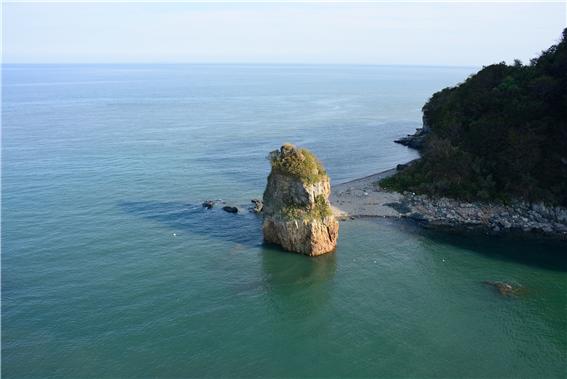
<Ice cream rock of Yeonpyeongdo Island> Photo by Ongjin County Office
<延坪岛冰淇淋岩>照片-甕津郡厅
■ Soyeonpyeongdo Island
小延坪岛
Soyeonpyeongdo Island is a small island with a surface of 0.236㎢, adjoined to Yeonpyeongdo Island. It is 6.4km south from Yeonpyeongdo Island and its magnificent view is formed along the 4.7km coastline with strange rocks and limestone such as Eolgulbawi Rock. Fish like bass, croaker, herring and rockfish are caught, as well as plenty shellfish such as oyster and conch near the seas in the area. Potato, corn and sweet potato are cultivated in the farmlands, but it is especially famous for their sweet potato’s great quality. Also, titanium, which is hard enough for usage to replace iron, is produced and there is a titanium gravelly field along the Oseok seaside, which is known for its fomentation effect.
小延坪岛面积为0.236㎢,是大延坪岛附带的小岛。它位于大延坪岛向南6.4公里处,顺着4.7公里的海岸线,头像岩等奇岩怪石与虫蚀石灰岩形成绝境。周边海上大量捕捉花鲈、鮸鱼、鲱鱼、石斑鱼等,牡蛎或海螺等鱼贝类也很丰富。耕地栽培土豆、玉米、甘薯等,尤其是甘薯美味而闻名。而且,生产可以替代铁使用的坚硬的钛,而钛矿所在的乌石海岸有磨耗的钛田,具有很好的热敷效果。
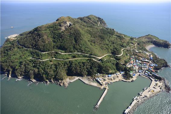
<The complete view of Soyeonpyeongdo Island> Photo by Ongjin County Office
<小延坪岛全景>照片_甕津郡厅
■ 「Special Act on Supporting the Five Northwestern Border Islands」 link
Published in
December 1, 2014
Modified in(1)
December 5, 2015
Modified in(2)
December 3, 2016
-
source
Research on the five northwest border islands’ total development plan establishment (2011), Korea Research Institute for Human Settlements, Ministry of Public Administration and Security
Natural environment of the five northwest border islands (2012), Natural Resources Research Division of National Institute of Environmental Research, Ministry of Environment
West sea’s South and North border line area plan for use to create the peace belt (2004), Kim Young-bong•Lee Moon-won•Cho Jin-cheol, Korea Research Institute for Human Settlements
Good islands for vacation Best 30 (2008), Regional Development Division of Ministry of Public Administration and Security
Guideline of security experience at the five Northwest border islands (Ongjin-gun), (2014), Development Division of Ministry of Public Administration and Security
Ongjin-gun tourism culture (www.ongjin.go.kr)


comment